
HISAR GEOSPATIAL
Hisar takes a single photograph, pinpoints where it was shot from the image content alone, no metadata needed, then tracks that location across current commercial satellite imagery to surface everything that moved, changed, or appeared.

From one image to the full picture
One image in, a complete geospatial picture out. Find where it was taken, verify it by satellite, then watch how the place changes over time. Every step, evidence-based.
Content-Based Geolocation
Hisar reads the image itself, not its metadata. Multiple AI models weigh terrain, skyline and mountain silhouettes, architecture, vegetation, signage and language, and the sun's angle to pinpoint where a photo was taken.
Confidence & Alternatives
No false certainty. Hisar returns the most likely location alongside ranked alternative candidates, each with its own confidence score, and clearly flags low-confidence cases for manual review.
Satellite Verification
Every hit is checked against current commercial satellite imagery, so an analyst can confirm by eye that the coordinate really matches the photo, building by building and feature by feature.
Change Over Time
Hisar lines up the area's satellite record date by date. Multi-temporal change detection automatically surfaces exactly what's different between captures, with every finding timestamped.
Movement & Object Detection
Aircraft on runways, vessels at berth, new or demolished structures, excavation and terrain shifts: detected, classified, and plotted on a timeline.
Manipulation Detection
Hisar cross-checks EXIF against what the image actually shows and hunts for signs of digital tampering, flagging fakes and mismatches for forensic and disinformation work.
Recognized from orbit.
When Hisar scans an area's satellite history it doesn't just register that pixels changed; it classifies the asset behind the change: unmanned aircraft, strike platforms, air-defense systems, and vessels.
Unmanned · UAV
UAVs operating over an area can be spotted and analyzed in satellite imagery. Our geolocation can also be integrated into the UAV itself, geolocating the footage it captures to turn it into intelligence.
Strike · UCAV
Combat aircraft and armed UAVs are picked out and analyzed the same way, straight from satellite imagery: what's parked, and where.
Air Defense
Ground systems and installations are located and assessed from satellite imagery, building a read on a site without anyone going near it.
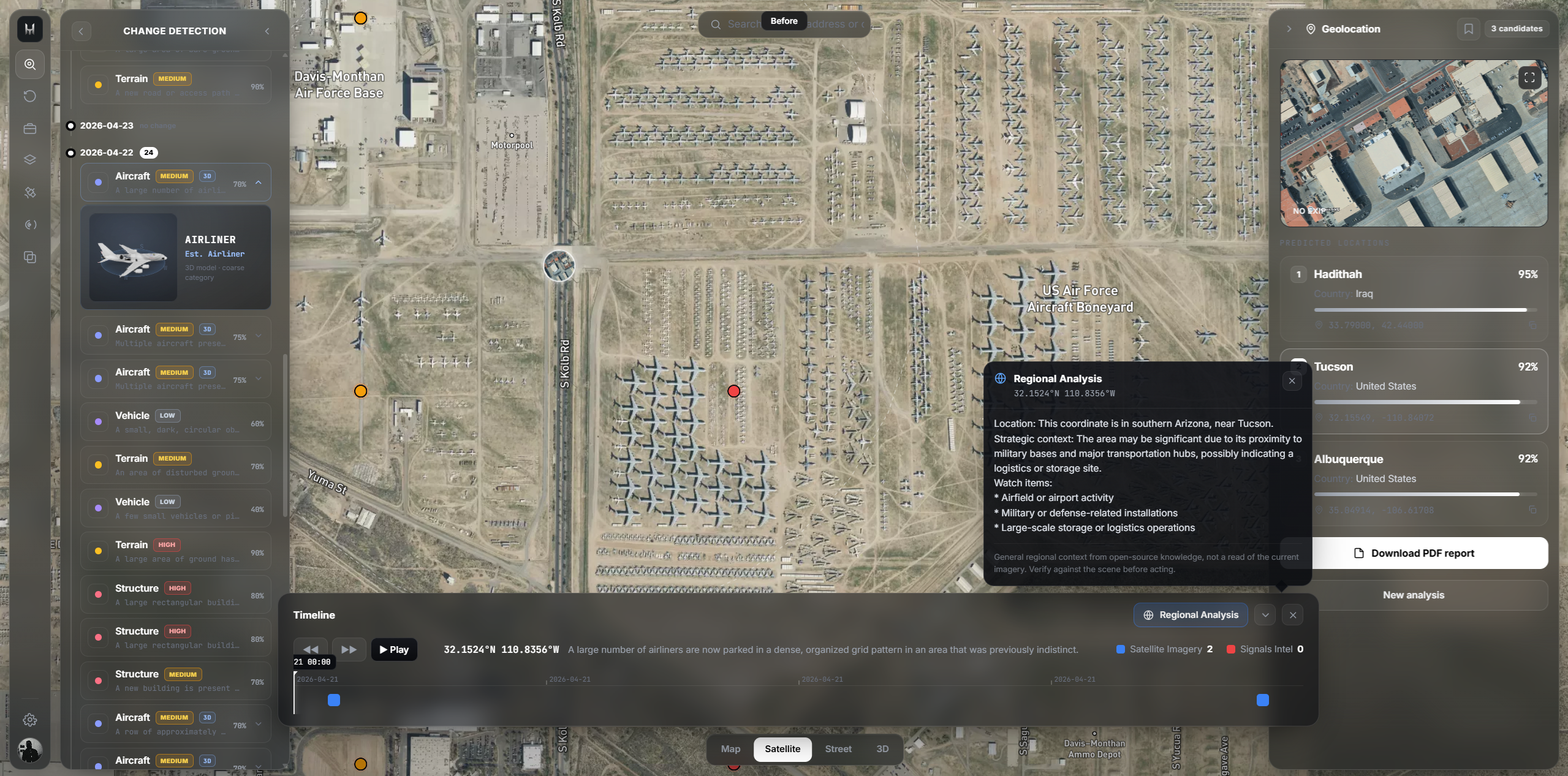
Everything that changed, on a timeline
Ask what happened at a coordinate and Hisar answers with dates: what was built, what was demolished, where activity spiked. Each change is pinned to the satellite frame that proves it.
Day by day
Built for the operations center.
Run Hisar wherever your operations live: on-prem, in your private cloud, or fully air-gapped. Imagery and findings never leave your network, integration is built around standard intelligence stacks, and the platform scales from a single workstation to a multi-region command.
Open API & integration
REST and gRPC services that drop Hisar into the intelligence stack you already run.
Sovereign deployment
Air-gapped installs, full data residency control, zero third-party cloud dependencies.
Access control & chain-of-custody
Granular classification controls and an immutable, court-ready audit log.
$ hisar locate --image recovered_frame.jpg \
    --changes 30d

[✓] Reading visual cues (terrain, skyline, signage)...
[✓] No EXIF, geolocating from content
[✓] Pulling current commercial satellite tile

┌─ RESULT
│ location        37.0079°N 35.3289°E
│ confidence      0.94 (top match)
│ alternatives    3 candidates
│ changes.30d     38 · 14 structures, 9 terrain
│ manipulation    none detected
└─ report ready · ticket #HS-44192

$
Get in touch
Questions, integrations or support. Our team replies within one business day.
Message sent
Thanks for reaching out. Our team will get back to you within one business day.
One image. The whole story.
Book a live demonstration with our team.